Historical data visualization · 1854
John Snow: the Broad Street cholera map
Soho, London · August and September 1854
- Source
- commons.wikimedia.org
- Retrieved
- 26 September 2026
- License
- Public domain (map); notice: MIT
- Rights holder
- John Snow, 1854
- Language
- English

About this edition and its rights
Edition
Digitally enhanced scan from the UCLA Department of Epidemiology, as uploaded to Wikimedia Commons (20124 x 18877 px), reduced to 4400 px and two tones for the poster. The notice below the map is not a period text: it was written for this poster.
Rights
John Snow died in 1858 and the map was published in 1855: it is in the public domain in France and in the United States. Wikimedia Commons marks the file as public domain.
The notice written for the poster is covered by the MIT license of this repository.
Notice#
A note written for this poster.
On 31 August 1854 cholera broke out around Broad Street, in the Soho parish of St James, London. Within three days 127 people living on or near the street had died, and by 10 September more than 300. Within a week, three quarters of the residents had fled.
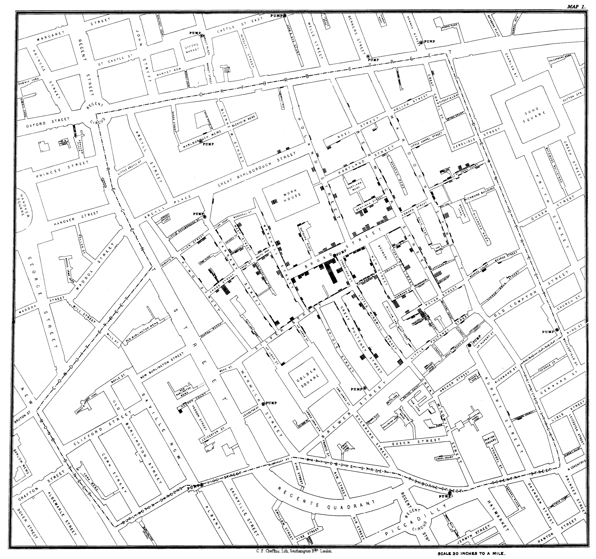
The physician John Snow had argued since 1849 that cholera spread through contaminated water, not through the bad air, or miasma, that most doctors blamed. He mapped the deaths house by house and found that nearly all had occurred close to the public pump in Broad Street, or among people who drank its water. On the evening of Thursday 7 September he put his evidence to the Board of Guardians of St James’s parish, and the handle of the pump was removed the next day, when the outbreak was already declining.
On the map, each black bar is one death, drawn at the house where it occurred, and the pumps are marked. The deaths crowd around Broad Street and thin out wherever another pump was nearer. The workers of the Broad Street brewery, who drank beer, were spared. The Reverend Henry Whitehead later traced the source to a cesspit beside the well, into which water used to wash the nappies of a sick baby had drained.
Snow published the map in 1855, in the second edition of On the Mode of Communication of Cholera. It is counted among the founding documents of epidemiology.