Historical data visualization · 1869
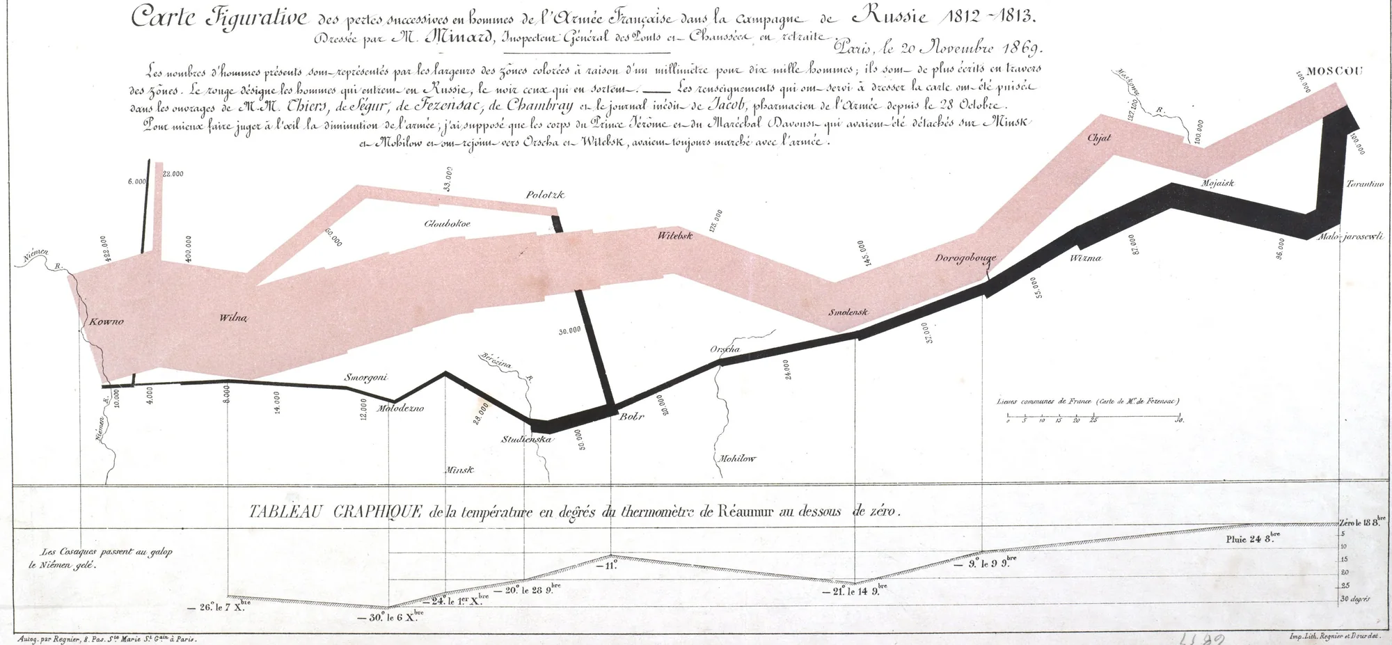
Charles Joseph Minard: Carte figurative des pertes successives en hommes de l’Armée Française dans la campagne de Russie 1812-1813
Paris · 20 November 1869
- Source
- gallica.bnf.fr
- Retrieved
- 27 September 2026
- License
- Public domain (map); notice: MIT
- Rights holder
- Charles Joseph Minard, 1869
- Language
- French
About this edition and its rights
Edition
Scan btv1b52504201x of the Bibliothèque nationale de France (département Cartes et plans, GE DON-4182: two maps on one sheet, 44.5 x 52 cm), as uploaded to Wikimedia Commons (File:Carte figurative des pertes successives en hommes de l’armée française dans la Campagne de Russie 1812-13 (comparées à celle d’Hannibal durant la 2èmee Guerre Punique) - Minard. Régnier & Dourdet - btv1b52504201x.jpg, 8809 x 7612 px). The poster shows the lower map only, cropped to its frame (the map of Hannibal’s march above it, the handwritten dedication and the library marks around the frame are left out), reduced to 4234 px and with its paper tone scaled to white (one gain per channel). The text is transcribed from the scan: the legend under the title, set in two paragraphs as on the map, the heading of the temperature chart and the note at its left. The title, author line and date of the map are in the header. The rule that separates two sentences of the legend is set as a dash; “M.M.” and “zônes” are kept as written; “l’œil” is read with the ligature, which cannot be told from joined script; the title’s “1812~1813” is set with a hyphen. The labels on the map (places, numbers of men, temperatures and dates) are not transcribed. No transcription of the legend was found to compare with: it was read on the scan word by word. The notice below the legend is not a period text: it was written for this poster from the map itself and the Gallica record (Minard’s dates, the printer, the two maps on one sheet).
Rights
Charles Joseph Minard died in 1870 and the map was published in 1869: it is in the public domain in France and in the United States. The Gallica record states “domaine public”; Wikimedia Commons marks the file as public domain.
The notice written for the poster is covered by the MIT license of this repository.
Legend#
As lithographed on the map.
Les nombres d’hommes présents sont représentés par les largeurs des zônes colorées à raison d’un millimètre pour dix mille hommes; ils sont de plus écrits en travers des zônes. Le rouge désigne les hommes qui entrent en Russie, le noir ceux qui en sortent. — Les renseignements qui ont servi à dresser la carte ont été puisés dans les ouvrages de M.M. Thiers, de Ségur, de Fezensac, de Chambray et le journal inédit de Jacob, pharmacien de l’Armée depuis le 28 Octobre.
Pour mieux faire juger à l’œil la diminution de l’armée, j’ai supposé que les corps du Prince Jérôme et du Maréchal Davoust qui avaient été détachés sur Minsk et Mobilow et ont rejoint vers Orscha et Witebsk, avaient toujours marché avec l’armée.
Below the map#
The heading of the temperature chart and the note at its left.
TABLEAU GRAPHIQUE de la température en degrés du thermomètre de Réaumur au dessous de zéro.
Les Cosaques passent au galop le Niémen gelé.
Notice#
A note written for this poster.
Charles Joseph Minard (1781-1870), a retired inspector general of the Ponts et Chaussées, drew this map in Paris and dated it 20 November 1869. It was printed by Regnier and Dourdet on one sheet with a companion map of the losses of Hannibal’s army on its march from Spain into Italy, dated the same day. The copy shown here, now in the Bibliothèque nationale de France, carries the handwritten dedication “pour la Bibliothèque impériale”.
The pink band leaves the Niemen, at Kowno, with 422,000 men and reaches Moscow with 100,000. The black band of the retreat leaves Moscow with 100,000 and comes back to the Niemen with 10,000. The chart below follows the retreat in degrees Réaumur below zero, down to 30 degrees on 6 December.